

Force protection & installation security (AT/FP)
Military base force protection — air-gapped, on one seat.
Nine shipped tools turn the workstation into an installation-security seat: physical-security inventory and FPCON posture, blast / standoff / quantity-distance screening, occlusion-aware sensor coverage on the real 3D scene, CBRN plume on live weather, evacuation and muster, Part 77 / AICUZ airfield surfaces, exercise injects with a clocked after-action review, CARVER scoring and a real-time security COP — with every compliance number cited to its public standard and every restricted table left as an empty, user-supplied slot.
FPCON Normal→DeltaDoD 6055.09-M QD arcsKingery-Bulmash overpressureUFC 4-010-01 / ISC standoffEN 62676-4 DORIERG 2024 · ATP-45-style14 CFR Part 77 + AICUZCARVER
Program facts
- Tools9 — Inventory & FPCON · Blast & Standoff · Sensor Coverage · Hazard Plume · Evacuation & Muster · Airfield Surfaces · Exercise & Risk · Indoor Floor Plans · Security COP
- VerificationFinal program sweep 1,940 assertions / 0 failed across 12 suites; independent code-review gate per workstream
- Stores5 open GeoPackages — protection · blast_assessments · airfield · exercise · indoors (EPSG:4326)
- APIREST + SSE families under
/api/protection/*; every FP layer rides the OGC API Features, MVT and FeatureServer facades - Real-timeEmbedded MQTT broker (MQTTnet) + connector framework — loopback-only, default-deny ACL; Traccar, ThingsBoard, TAK, rtl_433, ADS-B / AIS / Remote ID / radar
- PostureNo cloud calls; DPAPI-encrypted secrets; honest degrade when a sidecar is absent
Nine tools, one ribbon
Know it. Model it. Rehearse it.
Each workstream shipped behind its own review gate and test suite; each writes open GeoPackage stores and renders results as live map layers.
Inventory & FPCON
A geospatially grounded security picture instead of a spreadsheet.
- 13 asset kinds — fences, gates / ACPs, barriers, cameras, lighting, radar, critical buildings — with condition and criticality
- FPCON Normal→Delta with stricter-only area overrides and cumulative measure resolution
- Append-only audit history; import from GPKG / GeoJSON; 5-table protection.gpkg
- external_ids bind assets to their MQTT / Traccar / ThingsBoard telemetry
Blast & Standoff
Physics and public standards, computed on the real scene.
- DoD 6055.09-M quantity-distance arcs (HD 1.1–1.4, cube-root scaling, IATG 02.20 exposure rules)
- Kingery-Bulmash overpressure rings (Swisdak bands) + pressure-at-cursor probe
- UFC 4-010-01 / ISC standoff pass-fail per building; glazing hazard bands
- Free-air vs surface burst (W/1.8) handled in both directions; band edges verified continuous to under 1%
Sensor Coverage
Occlusion-aware footprints on DSM + LoD2.2 buildings — not 2D circles.
- Möller–Trumbore ray casting + BVH against the mesh
- DORI grading per EN 62676-4 (25 / 62.5 / 125 / 250 px/m)
- Radar horizon 4.12(√hr+√ht); lux via inverse-square
- Gap analysis + greedy placement suggester; capability-gated ONVIF PTZ discovery (off by default)
Hazard Plume (CBRN / HAZMAT)
Gaussian dispersion on live weather already in the app.
- 512×512 grid (~10 km downwind), Briggs σ, Pasquill A–F; METAR wind prefill
- ALOHA-style 3-tier LOC rings; AEGL / ERPG / IDLH table (22 chemicals)
- ERG 2024 protective-action distances + spill-size isolation circles
- ATP-45-style quick predict (1 km circle + ±30° sector) — labeled a public derivative, never the restricted tables
Evacuation & Muster
Building→muster assignment over the pedestrian network with capacity accounting.
- Roster + clear time (1.3 m/s default walk speed)
- Egress isochrones and catchments on the Valhalla / DuckDB routing stack; honest approximate:true beeline fallback
- Shelter advisor — downwind sector → shelter-in-place, muster suppressed
Airfield Surfaces
14 CFR Part 77 imaginary surfaces and AICUZ as generated 3D volumes.
- Civil §77.19, military §77.21, heliport §77.23 + EB-105A
- CZ / APZ-I / APZ-II polygons from the runway centerline
- Obstruction scan of DEM + user objects with §77.9 Form 7460-1 notice screens
- Every dimension cites CFR / UFC 3-260-01 / OPNAVINST
Exercise & Risk
Inject timelines that fire production paths, not a simulation stub.
- FPCON sets, geofence enqueues, fusion taps; per-inject → alert wall-latency capture
- Deterministic, self-contained HTML after-action review (byte-equal re-export)
- CARVER 6 factors + optional Shock, 1–5 and 1–10 scales, seeded from inventory criticality
Indoor Floor Plans
Stage-1 floor store per building.
- indoors.gpkg — UNIQUE building + level, idempotent import
- IFC storey extraction — per-storey hulls + IfcSpace polygons
- GeoJSON floors + georeferenced plan images (2-GCP similarity fit)
- Floor-scoped assets via a level selector
Security COP (real-time)
One alert model over every source, severity-gated by the live FPCON floor.
- Geofences, telemetry alarms, C-UAS detections, FPCON changes, broker health
- CHARLIE / DELTA escalates everything; SSE + StreamServer live layer + 100-alert backfill ring
- Embedded MQTT broker + connectors — loopback-only, default-deny ACL, payload caps
Mission chain
From inventory to exercised response
The tools compose into one workflow: the shared inventory feeds every model, the models feed the response plan, and the exercise engine proves the plan under clocked latency — all on the same scene, all offline.
- InventoryFences, gates, barriers, cameras, lighting, radar and critical buildings in one GeoPackage with criticality and condition; FPCON set, overridden per area, audited.
- ModelPlace a threat: QD arcs and overpressure rings screen standoff; occlusion-aware coverage finds the blind spots; the plume model predicts downwind zones on live weather.
- DecideEvacuation assigns buildings to muster points with capacity and clear time — or the shelter advisor says stay indoors because the hazard is downwind. Every number cites its source.
- RehearseExercise injects raise FPCON, trip geofences and push alerts through the production paths, with wall-latency capture and a deterministic HTML AAR.
- OperateThe live Security COP fuses MQTT sensors, Traccar tracks, ThingsBoard alarms, C-UAS detections and FPCON changes into one severity-gated alert stream on the map.
Standards-faithful, FOUO-honest
Every number cites its source
Public standards are embedded with citations; restricted tables are never faked; every value is user-overridable with its source recorded.
Embedded public standards
- ExplosivesDoD 6055.09-M · IATG 02.20 · Kingery-Bulmash / Swisdak
- StandoffUFC 4-010-01 · ISC RMP (public rows)
- Airfield14 CFR §77.19 / 21 / 23 · UFC 3-260-01 · OPNAVINST
- SensorsEN 62676-4 DORI
- HazmatERG 2024 · AEGL / ERPG / IDLH
Ships empty, user-supplied
- UFC 4-010-02Explosive weights I–IV — FOUO, empty editable slot; unconfigured query returns “not configured” with a null verdict
- ISC setbacks by FSLFOUO — empty editable slot; a populated slot wins over embedded public rows
- ATP-45(F)NATO-restricted — quick-predict table is a loudly labeled public-derivative placeholder
Disclaimers carried on every surface
- BlastPlanning aid — authoritative siting requires DDESB-approved ESS arcs (DDESB TP-26); pinned in the panel and on every REST response
- AirfieldNot a flight-certified system
- ChemistryAsphyxiants carry no LOC tiers; dense-gas screening flags when the Gaussian model is out of regime
In the product
Floating tool panels over the live installation map
Each force-protection tool opens as a panel in the FORCE PROTECTION ribbon group; results render straight onto the 3D scene as zones, rings, footprints and layers.
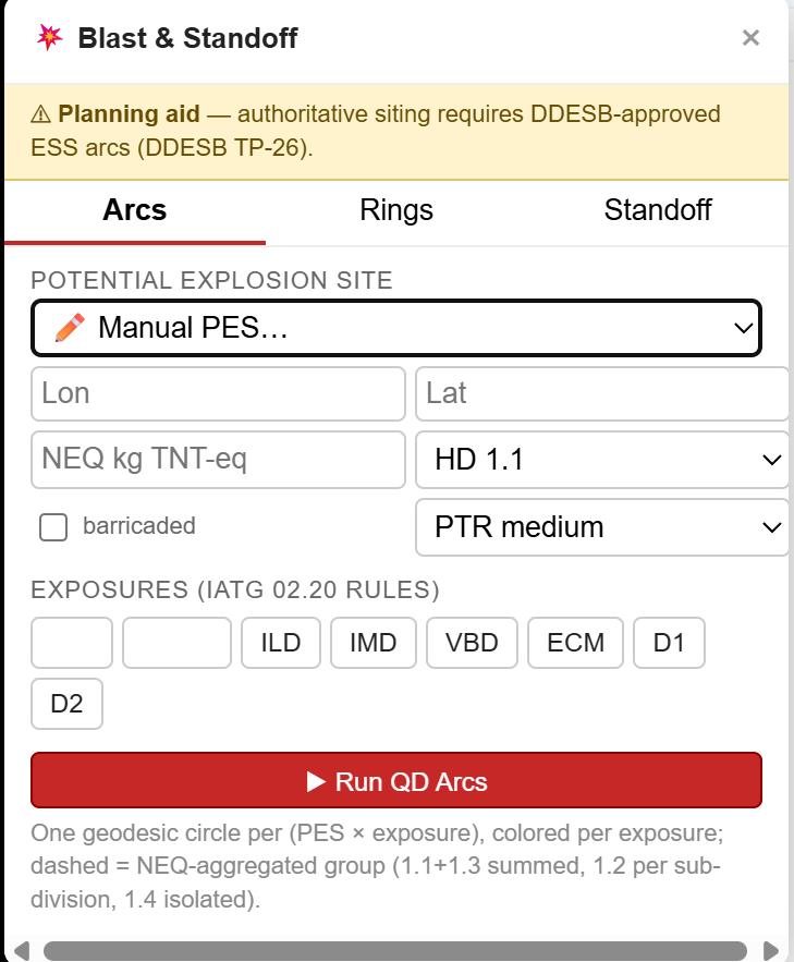
Blast & Standoff — PES site, NEQ, hazard division and exposures; QD arcs render as geodesic circles. The DDESB TP-26 planning-aid notice is pinned in the panel.
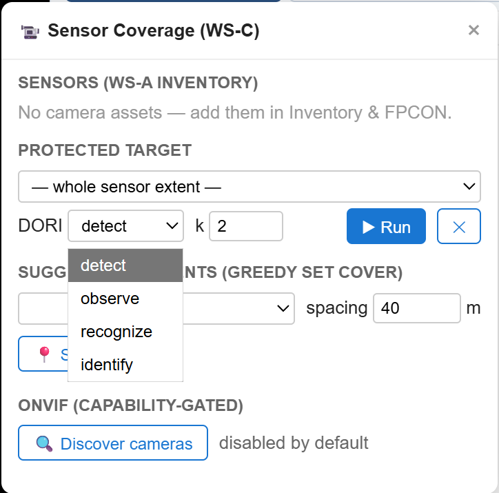
Sensor Coverage — DORI grade (detect / observe / recognize / identify), greedy placement suggestions, capability-gated ONVIF camera discovery.
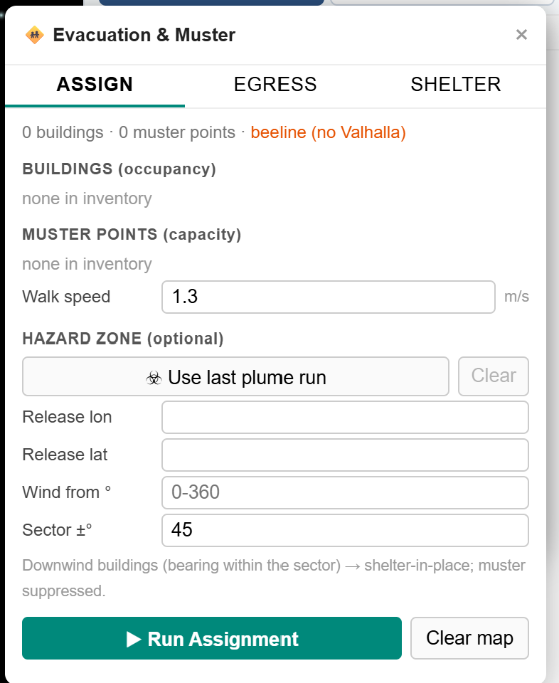
Evacuation & Muster — assign, egress and shelter tabs; walk speed, hazard sector from the last plume run.
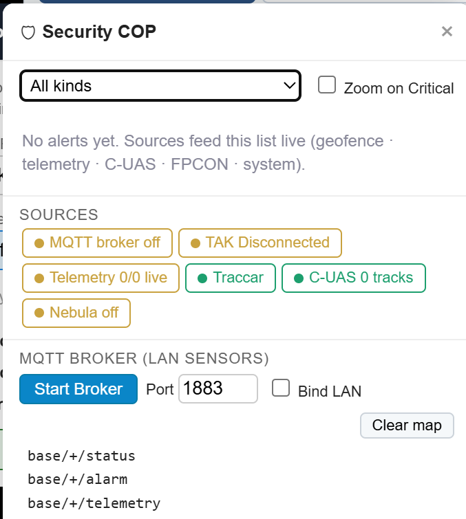
Security COP — one alert list fed by MQTT broker, TAK, telemetry, Traccar and C-UAS sources; embedded broker start/stop.
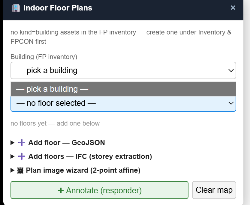
Indoor Floor Plans — GeoJSON floors, IFC storey extraction, georeferenced plan images per building.
Screenshot provenance
Unretouched captures of the shipped force-protection tool panels (August 2026 build). Sample inventories are empty by design — nothing here is a customer installation.
Honest scope
Planning aid, not siting authority
Defense buyers get burned by overclaims. This is the plain-language scope for this capability, drawn from the product’s own documentation.
- Shipped All nine workstreams — WS-RT / A (wave 1), WS-B / C / D / F (wave 2), WS-E / G / H1 (wave 3) implemented, independently reviewed and merged; final sweep 1,940 / 0, build 0 errors.
- Optional sidecar / gated ONVIF camera discovery — Capability-gated and off by default; camera footprints do not require it.
- Optional sidecar / gated NebulaStream connector — Complete and tested but disabled by default — research-grade, not production-hardened. Absence changes zero behavior.
- Roadmap Indoors stage 2 — Indoor routing and networks on top of the stage-1 floor store — muster routes that walk through buildings, not just to them.
- Roadmap Not claimed — DDESB-approved siting, the ATP-45(F) tables themselves, IndoorGML, indoor routing, ONVIF-on-by-default. This is analysis and planning support built from public standards — not a siting authority.
GeoTactical Insights · powered by 3D Map Explorer
Put an installation on lockdown — in a 30-minute demo.
Build the asset inventory, raise FPCON, screen a VBIED standoff, run a downwind plume, muster the buildings and replay an exercise with clocked alert latency — all on one machine, disconnected.
GeoTactical Insights
GEOINT and defense workflows powered by 3D Map Explorer, the air-gapped geospatial intelligence platform from Tech Maven Geospatial.